I had picked up the Land of Seven Rivers by Sanjeev Sanyal wanting a history re-brush of the Indian sub continent.
However the book focuses primarily on the Geography of Indian sub continent with a smattering of history thrown around.
And it fascinated me pretty much.
It is of course no surprise that there is much more to India than what we would like to believe.
The book covers the Indian Subcontinent right from the Pre-cambrian period, giving a bird's eye view on the formation of various geological features such as the Aravalli ranges, the Himalayas, the Gangetic plains etc and how civilizations thrived and folded through the ages upto the modern era.
There are numerous sites of significant Geographical and historical import scattered all around the country. Many a time one would have seen it or traveled across the same without being aware of its significance. I certainly have.
I will attempt to list a few of them here, with quotes liberally taken from the book, embellished with additional facts and pictures from the Internet.
Aravalli Ranges-'The oldest surviving geological feature anywhere in the world'

Map showing various ranges including Aravalli Ranges
Let us start with the Pre-Cambrian period.
More than a billion years ago,Earth had just one super continent called Rodinia.
This super continent broke up around 750 million years ago and the various continents began to drift apart. This period is known as the Pre-Cambrian period.
The author says that there is one remaining relic from the Pre-Cambrian period that is still very visible-the Aravalli range. It is arguably the oldest surviving geological feature anywhere in the world.
The Aravalli Range extends approximately 692 km in a southwest direction, starting from Delhi and passing through southern Haryana, through to Western India across the states of Rajasthan and ending in Gujarat.
The northernmost point of the Aravallis is the North Ridge near Delhi University.
The North Ridge was the stage for an important turning point in Indian history. It was here that a small British garrison held out in 1857 against a much larger force of Indian rebels.
A towering Mutiny Memorial was erected in 1863, in memory of the officers and soldiers of the Delhi Field Force who laid down their lives during the siege of 1857.

The Mutiny Memorial
On 28 August 1972 the Mutiny Memorial was renamed Ajitgarh and a plaque was put at its pedestal. Written in three languages Hindi, Urdu, English, It says that the “enemies” mentioned in the inscription were actually the freedom fighters and martyrs of India, who fought bravely against the repressive colonial rule in the First War of Indian Independence.
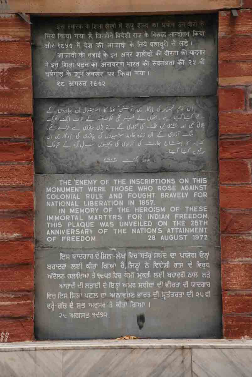
Ajitgarh Plaque
Farther south, near the Gujarat–Rajasthan border, the Aravallis briefly lay claim to being mountains rather than mere hills. The Guru Shikhar peak at Mount Abu rises to 1722 metres above sea level.

Guru Shikhar peak
Dinosaur Park of India
A large number of dinosaur remains have been found in Raioli village of Balasinor taluka, Gujarat. The site was identified in 1981 and appears to have been a popular hatchery as thousands of fossilized dinosaur eggs have been found there. Fossilized bones have also been found including those of a previously unknown predator that was 25–30 feet long and two-thirds the size of the Tyrannosaurus Rex. The animal has since been named Rajasaurus Narmadsensis (means Lizard King of the Narmada).
Rajasaurus Narmadsensis
The Indroda Dinosaur and fossil Park in Ahmedabad, is a park which houses the fossilized remains and the petrified eggs of the dinosaurs.

The Indroda Dinosaur and fossil park
Rock Caves of Bhimbetka
The Bhimbetka Rock Caves located in the Raisen District of Madhya Pradesh, about 45 kilometres Southeast of Bhopal, spans the prehistoric Paleolithic and Mesolithic periods, and exhibits the earliest traces of human life in the Indian subcontinent. It is a UNESCO world heritage site that consists of seven hills and over 750 rock shelters distributed over 10 kilometres. Discovered in the 1950s, the caves and rock shelters appear to have been inhabited almost continuously for over 30,000 years. Bhimbetka has rock paintings of animals and hunters from the Stone Age as well as of warriors on horseback from a later time (perhaps the Bronze Age). The paintings provide intriguing glimpses of the ancient origins of Indian civilization.
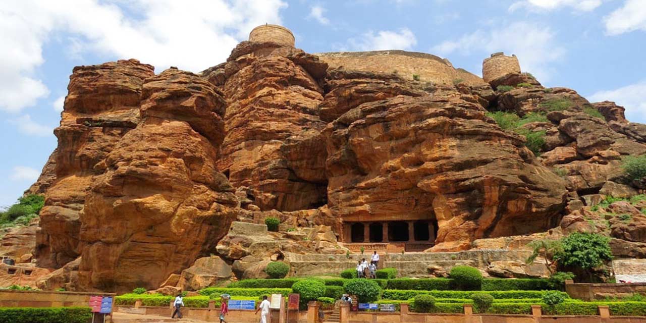

Bhimbetka Rock Caves
Dholavira- the largest Harappan Site
Dholavira is one of the five largest Harappan sites and the most prominent archaeological site in India belonging to the Indus Valley Civilization. Discovered in 1967-68, It is also considered as having been the grandest of cities of its time. Located in the Rann of Kutchh, the site was occupied from 2900 BCE, declining slowly after about 2100 BCE.
Dholavira is a good example of a large Harappan urban centre. At the centre of the settlement is a ‘citadel’ which contained the homes of the elite as well as public buildings. In front of the citadel there is a large ceremonial ground beyond which was the planned area where the common citizens lived.


Dholavira
Uttara path and Dakshina path
These ancient Highways, Uttara Path and Dakshina Path, played a very important role in shaping the political history of India. The geography of the great epics is intimately connected to these two great ancient trade routes. The locations mentioned in the Ramayana is oriented along the North–South axis while the Mahabharata is generally oriented on an East–West axis.
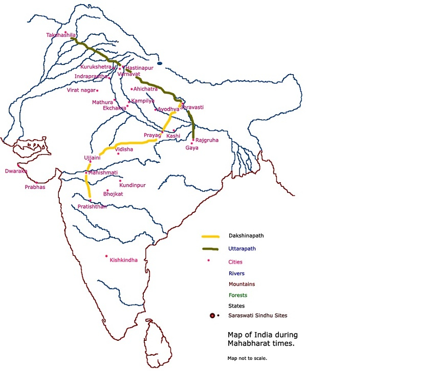
The Uttara Path was a well-trodden route by the Iron Age and formalized during the Mauryan Empire. Since then, it has been almost continuously rebuilt in some approximation to the original. Sher Shah Suri, the Mughals, and the British invested heavily in maintaining it. The British called it the Grand Trunk Road and it survives today as National Highway 1 between Delhi and Amritsar and National Highway 2 between Delhi and Kolkata, and is part of the Golden Quadrilateral network.
In contrast, the path of the Dakshina Path has drifted over time although certain nodes remained important over long periods. During the early Iron age, the Dakshina Path probably began near Allahabad, then went in a South -Westerly direction through Chitrakoot and Panchavati(near Nashik) and eventually to Kishkinda( Near Hampi). This would probably be the route followed by Rama during his exile.
Kishkinda
When Sita was abducted by Ravana, the powerful king of Lanka, Rama and his brother set out to find her. On the way, at a place called Kishkindha, they befriended a tribe of monkeys that promised to help them. Kishkindha, the kingdom of the monkeys is located near the medieval ruins of Vijayanagar at Hampi. The terrain consists of strange rock-outcrops, caves with Neolithic paintings, and bands of monkeys scampering over the boulders. It is such an evocative landscape that it is likely that Valmiki either visited it or had heard detailed descriptions of it from merchants plying the Dakshina Path or Southern Road. Not far away from this site is a sloth bear reserve that recalls Jambavan, Hanuman’s sloth bear friend.

Anjaneya parvat, the birthplace of Hanuman
Ram Sethu

Ram Sethu
Locations mentioned in Mahabharata
Many of the places mentioned in the Mahabharata are located around Delhi. For instance, Gurgaon, renamed recently as Gurugram, was a village that belonged to Dronacharya, the teacher who trained the cousins in martial arts. The name Gurugram literally means the ‘Village of the Teacher’.
The Pandav capital of Indraprastha is said to be located under the Purana Qila in Delhi. Similarly, the site of Hastinapur is identified with a site near modern Meerut. The battlefield of Kurukshetra is nearby, in the state of Haryana.
Ashoka Edicts
The Edicts of Ashoka are a collection of more than thirty inscriptions on pillars as well as boulders and cave walls, made by Emperor Ashoka of the Mauryan Empire during his reign, from 268 BCE to 232 BCE. These pillars and inscriptions have been found across the subcontinent from Afghanistan in the north to Karnataka in the south, Gujarat in the west to Bengal in the east.

The edicts describe in detail Ashoka's view about Dharma, an earnest attempt to solve some of the problems that a complex society faced and proclaim his adherence to the Buddhist philosophy.
Even though these edicts were discovered and were in the process of being deciphered from the beginning of the 19th century, it was only in 1915 that the identification of the Emperor named as Piyadassi in the edicts was linked to Asoka by C. Beadon, a British gold-mining engineer, at Maski, a village in Raichur District of karnataka.
Besides a few inscriptions in Greek and Aramaic (which were only discovered in the 20th century), the Edicts were mostly written in the Brahmi script and sometimes in the Kharoshti script in the northwest, the two Indian scripts used at that point in time.


Edicts of Asoka
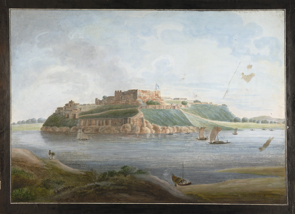
Chunar Fort
The youngest of India’s geological features—the Gangetic plains started out as a marshy depression running between the Himalayas and the mountain range of the Vindhyas. The Ganga’s southward drift was arrested only when it nudged into the Vindhyas near Chunar (close to Varanasi). It is the only place in the plains where a hill commands such a view over the river, making Chunar fort a coveted strategic location. It was once said that he who controlled Chunar fort also controlled the destiny of India. A walk through the fort is a walk through Indian history. The walls resonate with tales of the legendary King Vikramaditya, the Mughals, Sher Shah Suri and Governor-General Warren Hastings.
Chunar Fort
Fort of Prithviraj Chauhan
Qila Rai Pithora, also known as Rai Pithora's Fort, was a fortified city built in the 12th century by Prithviraj Chauhan. Remains of the fort walls are scattered across South Delhi, visible in present Saket, Mehrauli around Qutb Complex, Kishangarh and Vasant Kunj areas
.jpg)
Qila Rai Pithora
Hampi
In 1336 CE, the Vijayanagara Empire arose and grew into one of the famed Hindu empires of South India that ruled for over 200 years. The Vijayanagara Empire built its capital around Hampi, calling it Vijayanagara. By 1500 CE Hampi-Vijayanagara was the world's second-largest medieval-era city after Beijing, and probably India's richest.
In 1565, at the Battle of Talikota, a coalition of muslim Sultanates entered into a war with the Vijayanagara Empire. They captured and beheaded the king, followed by a massive destruction of the infrastructure fabric of Hampi and the metropolitan Vijayanagara. The city was pillaged, looted and burnt for six months after the war, then abandoned as ruins.

Hampi
Forts of Diu
Portuguese control over the Indian Ocean was based on a network of forts along the coast. The best preserved of these forts is in Diu, a small island just off the Gujarat coast. The fort ramparts offers beautiful views of the Arabian Sea and has an impressive array of sixteenth- and seventeenth-century cannons.
The fort was built in 1535 subsequent to a defense alliance forged by Bahadur Shah, the Sultan of Gujrat and the Portuguese when Humayun, the Mughal Emperor waged war to annex this territory. The fort was strengthened over the years, till 1546. Portuguese ruled over this territory from 1537 (from the year they took control of the fort and also the Diu town fully) till 1961 (for 424 years, the longest period by any colonial rule in the world)till they were forced to quit in December 1961.

Diu Fort
Gurdwara Sis Ganj Sahib
Gurdwara Sis Ganj Sahib is one of the nine historical Gurudwaras in Delhi. It was first constructed in 1783 by Baghel Singh Dhaliwal to commemorate the martyrdom site of the ninth Sikh Guru, Guru Tegh Bahadur. Situated in Chandni Chowk in Old Delhi, it marks the site where the ninth Sikh Guru was beheaded on the orders of the Mughal emperor Aurangzeb on 11 November 1675 for refusing to convert to Islam and protesting against the forceful conversion of Kashmiri Pandits and dharmic people. However, before their body could be quartered and exposed to public view, it was stolen under the cover of darkness by one of his disciples, Lakhi Shah Vanjara who, then burnt his house to cremate Guru's body; today, at this site stands Gurudwara Rakab Ganj Sahib.

Gurdwara Sis Ganj Sahib
Minto Park
Minto Park, officially Madan Mohan Malaviya Park, is a park in Allahabad, located in the southern part of the city along the banks of Yamuna River. It is a historical site wherein in 1858, Lord canning read out the declaration of Queen Victoria's Proclamation which resulted in the complete transfer of control over India from The East India Company to the Government of Britain. The park is named after Earl of Minto, who in 1910, laid a Column with a four-lion symbol on the park to commemorate the event.
The column commemorating the Queen’s Proclamation, after independence, has been capped with a replica of the national emblem, the Mauryan lions and the wheel.

Minto Park
The focus of the book has generally been North Centric, probably because that is what captures the popular imagination. There would be similar such gems littered all over the North East India and other remote parts of South India for certain.
The focus of the book has generally been North Centric, probably because that is what captures the popular imagination. There would be similar such gems littered all over the North East India and other remote parts of South India for certain.